MOSER ACTIVE's Hiking Guide for Torres del Paine National Park
The Moser Active Torres del Paine Hiking Guide is designed to help you plan your Patagonia hiking trip and find the right tour for your fitness level and the number of days you want to spend in the Torres del Paine National Park. We also provide lots of useful information about trekking in Torres del Paine and answer many questions that hikers have asked us over the last 20 years.
Torres del Paine National Park
is located in the far south of the Chilean part of Patagonia and can be reached by land from Puerto Natales in around 2 hours/130 km. The most famous national park in Patagonia was declared a UNESCO biosphere reserve in 1978. Rugged peaks, shimmering turquoise lakes, glaciers and a variety of wildlife are spread over an area of 242,000 hectares.
The Torres del Paine O Circuit and the Torres del Paine W Hike are the two most famous, multi-day hiking routes within Torres del Paine National Park.

Frequently Asked Questions - Do you plan a trip to Torres del Paine?
Torres del Paine W HIKE OR O TREK?
The Torres del Paine W Hike and the O Trek both are classical trekking routes through Torres del Paine National Park. The trails can be combined to create a longer trek. The Torres del Paine O Loop starts at the Guarderia Laguna Amarga and leads counterclockwise through the entire park (usually taking seven days). You experience Andean desert landscapes as well as primeval forests, swamplands, high mountain passes, vast glacier tongues and pointed rock needles in front of ever-changing cloud formations.
The Torres del Paine W only crosses the southern part of the national park. It leads you into the most beautiful valleys, the Valle del Francés and the Valle Ascencio. The northern part of Torres del Paine O-Circuit trek is the less populated of the two treks as the number of hikers per day is limited to 100, while the number of hikers per day on the "W" is limited to approx. 200-300 a day.
HOW MANY DAYS DO I NEED FOR THE Torres del Paine O CIRCUIT?
The Torres del Paine O-Circuit or O-Trek is approx. 117 km/73 miles long and takes at least seven days to complete. It adds a northern section of hiking on to the W Trek, including John Gardner Pass. The Torres del Paine Full O Circuit is suitable for more experienced hikers, due to its longer distance and necessity for backcountry camping, but the remarkable views are well worth it. This route circumnavigates counterclockwise the entire Paine range without the crowds of the W-Hike (at least in the northern part of the Park), providing more opportunities for off-the-beaten-path discoveries and solitude.
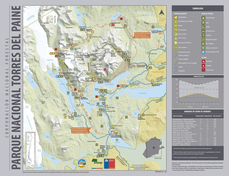
TORRES DEL PAINE TREKKING MAP
CAN I DO THE TORRES DEL PAINE O CIRCUIT IN 7 DAYS?
Yes, you can hike the Torres del Paine O Circuit in 7 days (suggested itinerary):
Day 1 - Transfer Puerto Natales to Torres del Paine National Park; Trek to Puesto Serón; Campsite Serón (hiking time: 4-5 hours, hiking distance: 12 km)
Day 2 - Trek to Refugio Dickson; Campsite Dickson (hiking time: 6-7 hours, hiking distance: 18.5 km)
Day 3 - Trek to Puesto Los Perros; Campsite Los Perros (hiking time: 4-5 hours, hiking distance: 9.5 km)
Day 4 - Trek to Refugio Grey, crossing John Garner Pass; Campsite Grey (hiking time: 8-10 hours, hiking distance: 22 km)
Day 5 - Optional kayaking Grey lake or ice hiking on Grey glacier; Trek to Lake Pehoe; Campsite Lodge Paine Grande (hiking time: 4-5 hours, hiking distance: 12 km)
Day 6 - Trek to the French Valley; Campsite Lodge Paine Grande (hiking time: 6-7 hours, hiking distance: 18 km)
Day 7 - Catamaran ride Lake Pehoe, Transfer to Las Torres sector and Trek to the Torres del Paine towers (hiking time: 8 hours, hiking distance: 19 km). Transfer back to Puerto Natales.
Torres del Paine with a tour operator or independently?
A local Torres del Paine tour operator, like MOSER Active, can provide peace of mind, thanks to their experience and expertise in the region, as well as guides who have spent hours on the same trails you will hike. In addition, a local agency can provide porter service to assist on your trek and, should the need arise, are able to provide emergency assistance and first aid. Every year inexperienced hikers get lost or even lose their lives. Choosing a local travel company also supports the community you are visiting and promotes mindful travel practices.
If you book the Torres del Paine O Trek with MOSER Active, a certified and experienced trekking guide and porters for tents and personal belongings are always included in the trip price.
Do I need a guide and porter hiking the Torres del Paine O Trek?
An experienced MOSER Active guide means you are a lot safer. The guide would bring a satellite phone along to call out for help if needed. Your guide will know the tricky parts of the Torres del Paine trails and can give you a lot of information on what you are observing alongside the trails, about animals, plants, geology, people and culture. Walking with a porter also means decreasing the weight of your backpack as you won't have to carry your tent, sleeping bag and sleeping mattress. Even if you’re accompanied by a professional certified guide, make sure you are fit enough to do a demanding trek of several days.
WHY SHOULD I TREK IN TORRES DEL PAINE ONCE IN A LIFETIME?
- Torres del Paine National Park is one of the most popular national parks in Chile and the entire Andes region, and for good reason: The peaks rise up in ragged glory, the fauna is incredibly various and the glaciers are (still) of an astonishing length.
- A Patagonia trekking tour takes you through different landscapes and even several climate zones in a day. Even though the highest peaks are not even 3,000 meters high, you can find conditions as if you were in high alpine altitudes, especially when crossing the John Gardner mountain pass (1,250 meters). In the French, Bader or Ascencio valleys, it can be very warm and tropically humid.


WHAT TO DO WHEN ALL OF THE CAMPSITES IN TORRES DEL PAINE ARE FULLY BOOKED?
Due to the huge demand for Torres del Paine trekking tours, many campsites in Torres del Paine National Park are fully booked very early. As one of the leading local tour operators, MOSER Active offers a variety of organized and guided hiking trips to Torres del Paine with weekly departures, where you can still find available spots.
If you book one of our guided Torres del Paine tours (Torres del Paine W Hike or Torres del Paine O Circuit), we take care of the entire organization on site. So, it is worth taking a look at our Torres del Paine guaranteed departures, even if you have not gotten on your planned arrival date a Torres del Paine campsite reservation online anywhere else!
How to get TO TORRES DEL PAINE NATIONAL PARK?
By plane to Santiago de Chile. In high season, continue by domestic flight to Puerto Natales, otherwise to Punta Arenas. From there, take the regular bus (hourly connection) to Puerto Natales. Alternatively, to Buenos Aires and via El Calafate (Argentina) by regular bus to Puerto Natales. From Puerto Natales by regular bus (departures 7:30 am and 2:30 pm) or private transfer to Torres del Paine Nationalpark - Laguna Amarga, then a 90-minute walk or minibus shuttle to Las Torres Hotel.
When Is the Best Time to Visit Torres del Paine?
The most ideal months to visit Torres del Paine National Park are November through February. However, to avoid crowds and ensure a bit more solitude on your hikes, consider visiting Torres del Paine in the shoulder seasons of October, March and April. If you don’t mind the cold, give some thought to a winter trek in June, July or August.
WHAT IS THE WEATHER LIKE IN TORRES DEL PAINE?
In Patagonia, the weather can change several times a day or even in an hour. You can experience summer heat and snowstorms in a very short period of time. A constant is the wind, which can be quite strong. You will notice that especially on the days you will cross mountain passes. Thunderstorms, however, are very rare.
Book your next Torres del Paine Adventure now !

Are There Off-the-Beaten-Path Day Hikes in Torres del Paine National Park?
For those hoping for peace and quiet, surrounded by Torres del Paine’s majestic landscapes, there are several hidden gems.
- Opt for the gentle Laguna Verde (Mirador del Toro) tundra trek, to the south of the W Trek’s main trails. The views of the Paine Massif are stunning, and wildlife abounds.
- Consider the Pingo Valley trek for jaw-dropping vistas of Paine Grande, the Olguin mountains and Zapata mountain. Not many hikers make their way to this off-the-beaten-path hiking region in Torres del Paine National Park, to the west of Lago Grey. In fact, you’ll likely see more Huemul deer than other people. Impressive waterfalls punctuate your hike through vast valley and lenga forest. Explore (with a guide) the Pingo and Zapata glaciers.
- A third less popular, but still abundantly beautiful, hike is the Mirador Ferrier trek, to the west of Torres del Paine National Park. You won’t find many other hikers on the trail and the payoff after a steep, two-hour climb is huge – a rarely seen perspective on the park, including the Paine Massif, Grey Glacier and just about all of the park’s shimmering blue lakes.
WHY SHOULD I BRING MOSQUITO REPELLENT?
The Patagonian summer (which would be the European winter) is the season mosquitoes like most. As a lot of campsites are situated by the river, you can make your evenings much more enjoyable if you bring along mosquito repellent.
DO I NEED TREKKING POLES on the Torres del Paine Trails?
We highly recommend hiking the Torres del Paine Loop with trekking poles. Trekking poles are a great help when crossing small rivers, slippery slopes and muddy terrain. If you do not bring your own, so you can rent them from MOSER Active.
CAN I DRINK FROM THE RIVERS AND LAKES?
Yes. Every day you hike along the Torres del Paine W Trail and the O Trail you can find fresh drinking water along the way. There is no need to carry huge amounts of water with you. The water is perfectly clean (almost) everywhere. In this case as well, you are better off with a guide, who knows where to find the highest-quality drinking water.
What Wildlife Will I See in Torres del Paine?
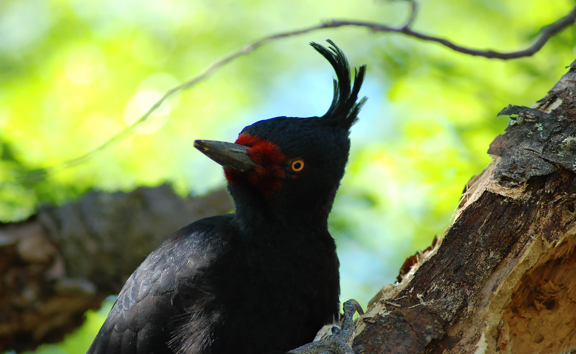
In between mesmerizing views of the towers and the blue lagoons, hikers in Torres del Paine will see an array of wildlife, including 26 species of mammal and more than 100 species of bird. Look for the guanaco, the puma, the South Andean Deer, the huge Andean Condor, grey fox, armadillo and more.
Do I need a vaccine when hiking in Paine Park?
There is no obligation to get specific vaccinations when traveling to Chile.
Travel Story about Torres del Paine O Circuit
THROUGH MEADOW FLOWERS AND A PRISTINE VALLEY
The hike along the O-Trek begins with registration at the Hotel and Camp Las Torres, the last post of civilization. The number of trekkers is limited, the full O-Circuit may only be hiked in an anti-clockwise direction and campsites must be reserved. This serves to protect the sensitive fauna and flora of the park and also the safety of the hikers: If a registered group or individual does not pass the ranger checkpoint or arrive at the campsite by a certain time, a search party may be sent. However, you should not rely on this. From the Hotel Los Torres, the hiking trail on the first day's stage always heads north, into the more secluded part of the national park, which only five percent of hikers visit. While you initially tread in the shadow of the 2,670-metre-high Monte Admiral Nieto, which was the first peak in the region to be climbed in the 1930s, the mountains reveal their gentler side as this first stage progresses: Endless meadows, covered with colorful, fragrant flowers - mainly less exotic daisies, cranesbill, ribwort plantain and sweet pea - between which wild geese waddle, leisurely meandering streams and rivers. Airy fleecy clouds drift over the picture-book idyll.
.
Vera shows us edible chokeberries, wild currants, foxberries and calafate berries from the barberry bush. "They say that once you've tasted the calafate berry, you'll come back to Patagonia," she says with a laugh. Later, we taste the "Pan de Indio", "the Indian bread", an edible mushroom that grows on the trunks in the southern beech forest. "The three southern beech species, which are only found in Patagonia and Tierra del Fuego, grow extremely slowly. These trees are therefore ancient," Vera emphasizes. Lichens grow on the trunks like beards. Palomitas, delicate white orchids, grow between them.
.
In the Serón sector above the camp of the same name, we look down on the valley of the Paine River, which is unique in its originality. "165 million to 135 million years ago, there was an ocean here," explains Vera. Volcanic eruptions under the surface of the water caused layers of sediment to form. Later, when the Nazca plate began to slide under the South American plate, the mountains folded up. Several ice ages eventually created the rugged towers that characterize today's hike to Camp Serón. "From now on, we will hike through completely different landscapes every day," Vera promises, "today we are in the pre-Andean scrub zone, tomorrow we will pass through Nothofagus forests. After the Garner Pass, the Andean desert awaits us.
.
ENCOUNTER WITH THE "PATAGONIAN BREATH"
The Torres del Paine National Park has been a UNESCO biosphere reserve since 1978. Covering an area of 242,000 hectares, it boasts vertical granite peaks, huge glaciers, lakes in every shade of green and blue imaginable and rushing waterfalls. Although the mountains barely scratch the 3,000-metre mark, the conditions on the passes are the same as those at an altitude of over 3,000 meters. "The tree line is at 700 meters and even in summer, the precipitation above this altitude falls as snow," explains Vera. In the valleys, on the other hand, it can be warm and even tropically humid. An average of 150,000 people visit the Torres del Paine National Park every year.
.
When we arrive at Camp Serón, we pitch our tent among the meadow flowers. A mighty griffin, a carancho, searches the ground for food without hesitation. The sun sinks spectacularly behind a nearby range of hills, setting the scene for a starry night. More wilderness romance is not possible! The next day, we head past Lago Paine and along the river of the same name. Plank paths lead through an extensive swamp area. The peaks make their hanging glaciers sparkle, fast-moving clouds create an exciting interplay of light and shadow. But then Patagonia shows its true face: the wind tugs at your rucksack and whistles through your jacket. The strong Patagonian wind, which no stiff North Sea breeze can compete with, comes out of nowhere. Walking becomes twice as difficult when you have the "Patagonian breath" against you, but when it comes from behind, your feet become unusually light. In the strong gusts, you get the pleasant feeling of flying - with heavy luggage on your back.
.
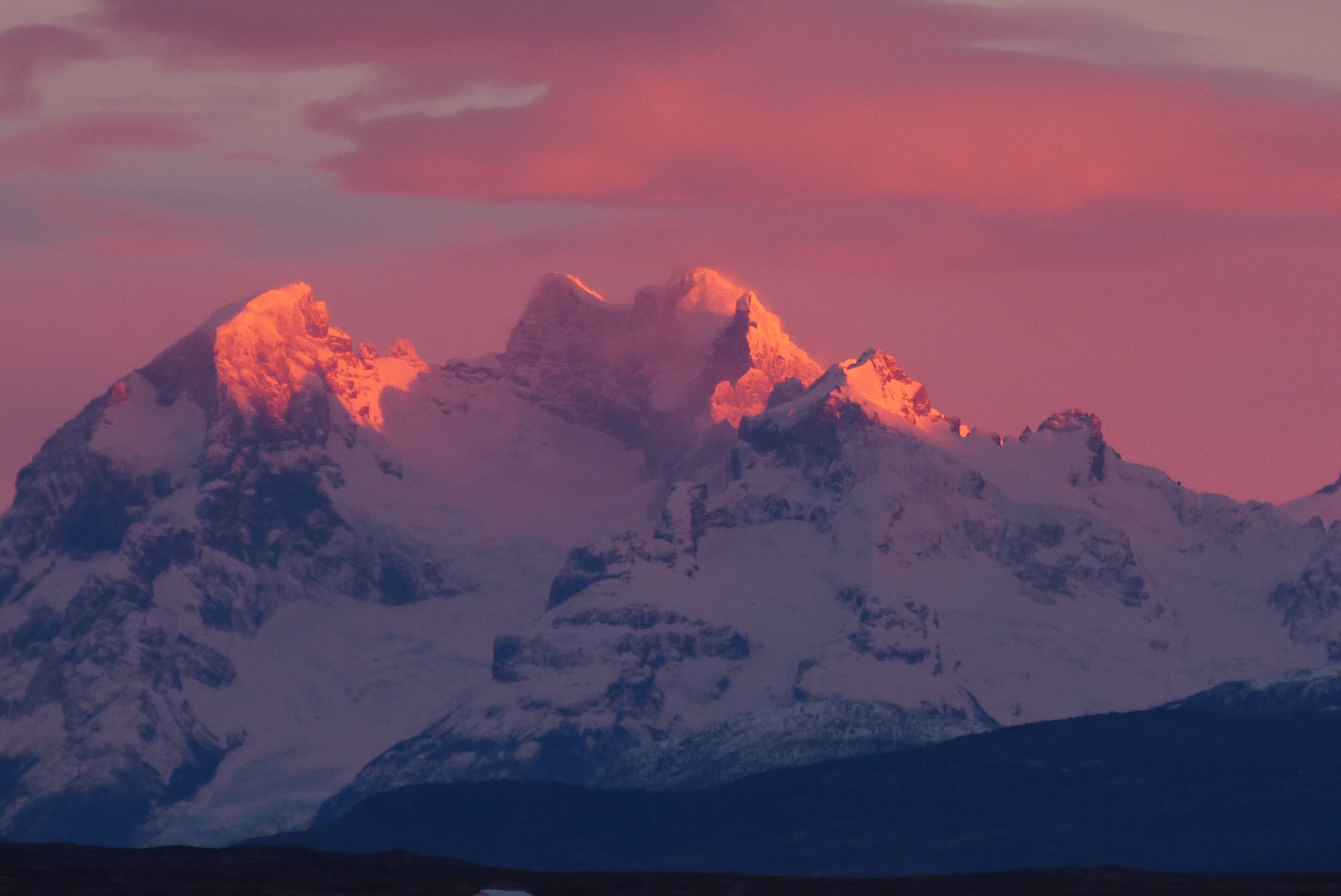
At the Refugio and Camp Dickson, the next stage destination in the very north of the Torres del Paine massif, we make the acquaintance of another Patagonian natural phenomenon: mosquitoes. Despite the mosquito spray, they spoil our enjoyment of the evening atmosphere on the sandy shores of Lago Dickson. A lonely, bizarrely shaped ice floe floats on it. "Lago Dickson is fed by the Dickson Glacier, which is already part of the great Patagonian ice sheet," reports Vera, "and it also feeds the Paine River. The evening sun makes the exciting mountain architecture that rises behind the lake glow in all its colorful glory. It turns purple, then the color fades to bluish. Paine means "blue" in the indigenous Tehuelche language. In the evening hours, you can understand why.
.
GARNER PASS AND GREY GLACIER
Behind the camp at Lago Dickson, the trail leads through an ancient, fairytale-like southern beech forest to Camp Los Perros, which is beautifully situated at the foot of the glacier of the same name. A lake has formed in a rocky basin below the glacier. From the shore, you could spend hours watching chunks of ice cascading down the glacier into the lake. During the natural cinema show, we snack on the not particularly tasty but nutritious chaura berries that grow in large numbers around the shore. "That's the good thing about Patagonia: You can find edible fruit, you have fresh drinking water everywhere and there are no ticks, poisonous spiders or snakes," Vera emphasizes. You don't even have to worry about thunderstorms. They hardly ever form in Patagonia.
.
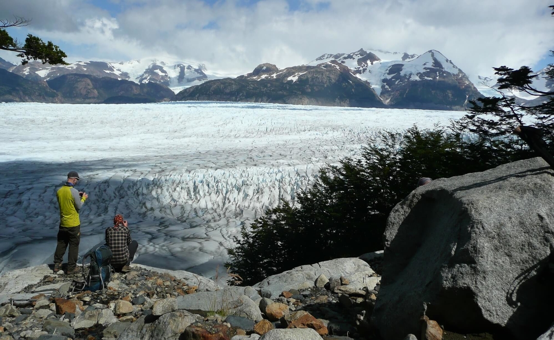
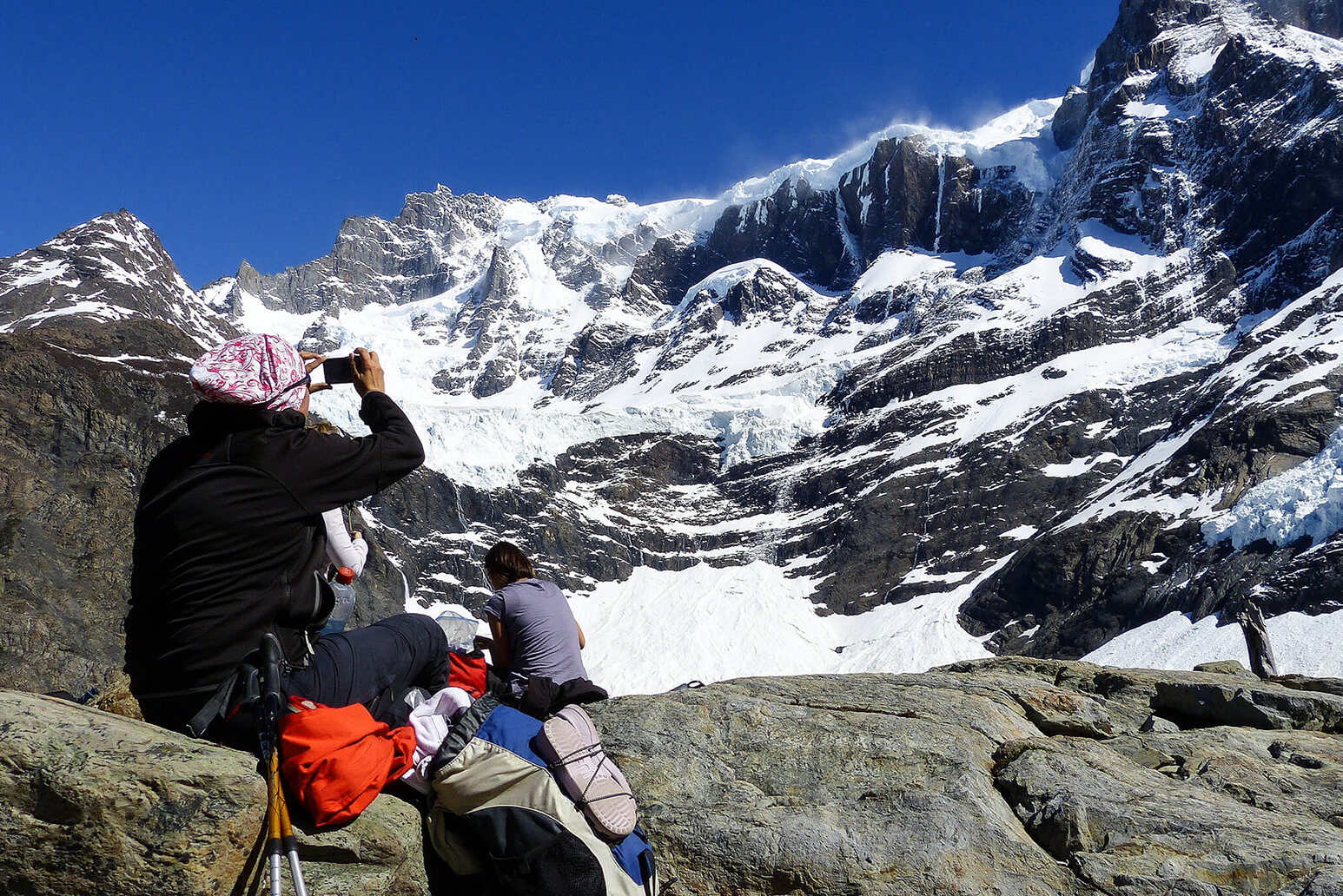
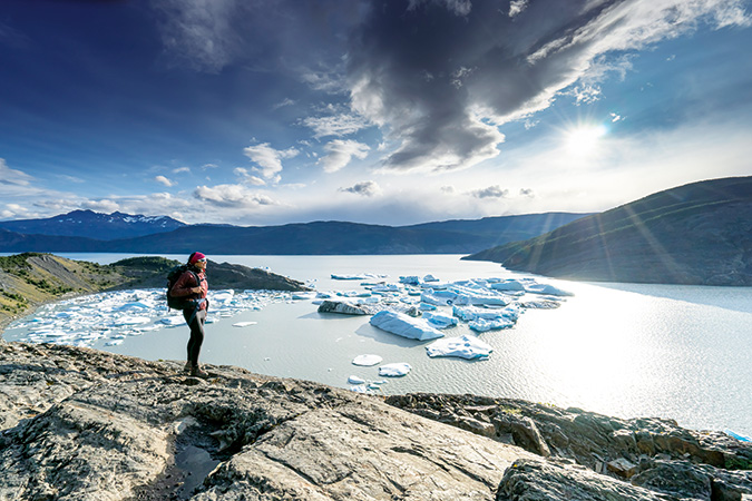
Day four of the Torres del Paine O-Trek is the decisive day with the crossing of the John Gardner Pass: The pass, which was originally called Paso John Gardner but lost its "d" over the years, is just 1,250 meters high. Some alpinists may smile wearily, but the 750-metre ascent is a tough one. Between the glaciers on the slopes of Cerro Amistad and Cerro Blanco Sur, we sweat our way steeply up over coarse scree. At the top of the pass, which forms the weather divide, an icy wind awaits us, but also a view that is second to none: We look out over the Grey Glacier, part of the Chilean ice sheet, the largest continuous ice mass outside the two poles. It is still far below our feet, but we have a complete view of the 25-kilometre-long glacier and can see how it calves into Lago Grey. The further we descend, the more clearly we can see the huge crevasses and ice floes as high as houses floating in the water. An excursion boat looks tiny in between. With immense pressure, the rapidly melting glacier pushes the masses of ice into the lake, the color of which already resonates in the name "Lago Grey". When we reach the edge of the ice flow, we can even hear the creaking and cracking of the ice. But soon everything is drowned out by the whistling of the wind, which carries away every word - and every unattached hat. We can't get enough of the perfectly curved glacier tongue, which presents itself to us, glistening innocently white, from ever-changing angles as we hike along it. As a result of global warming, however, the ice fields in Patagonia are also shrinking. "Over the past hundred years, the glacier has retreated by several kilometers," explains Vera. The Italian monk Alberto de Agostini, who made the first inland ice crossing in the 1930s and made Patagonia internationally famous with his photographs, was presented with a completely different picture.
.
ANOTHER TURQUOISE LAKE
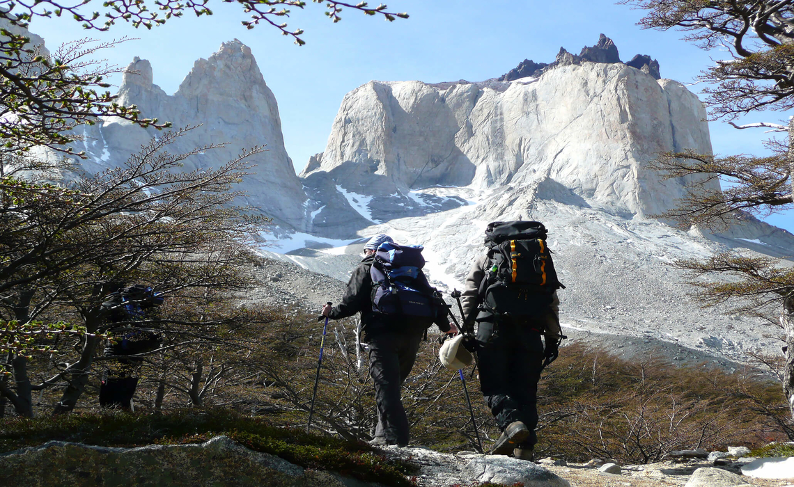
Arriving at Refugio/Camp Grey after five days of solitude, you are almost overwhelmed by the hustle and bustle. This is where the first leg of the W-hike ends. The next day's stage to Camp and Refugio Paine Grande is not only characterized by encounters with many other hikers, but also by the traces of the devastating forest fire in 2012. The landscape appears almost surreal: the charred trees, between which the new greenery is still sprouting, stand in sharp contrast to the untroubled idyll of the mountain landscape behind them. At Punta Bariloche, the Paine Grande stretches its pointed spikes into the sky like crooked predator teeth. Then you reach the emerald-green Lago Pehoé, whose name means "turquoise" in the indigenous Tehuelche language. This is where the catamarans dock, allowing you to cross over to Pudeto, where you can reconnect with civilization, under the mountain backdrop of the "Cuernos" and past two mighty waterfalls. Alternatively, you can continue on foot to the Refugio Los Cuernos and then over the middle peak of the W-trek, the Valle Francés, the "French Valley". The steep path offers fantastic views of the Paine Grande, the largest mountain in the national park at 3050 meters, with its many hanging glaciers. After returning to the Los Cuernos refuge, the last leg of the W-trek and the ascent through the Valle Ascencio await. "Ascensio was a notorious cattle thief who retreated here," explains Vera. There is no trace of the loneliness of that time today, but the magic of the mountains is still there. The moment of exhilaration at the brief but intense sight of the Torres - moments like these are simply worth returning to this alpine wonderland again and again?
.
MAGNIFICENT ROCKS IN A MYSTICAL VEIL
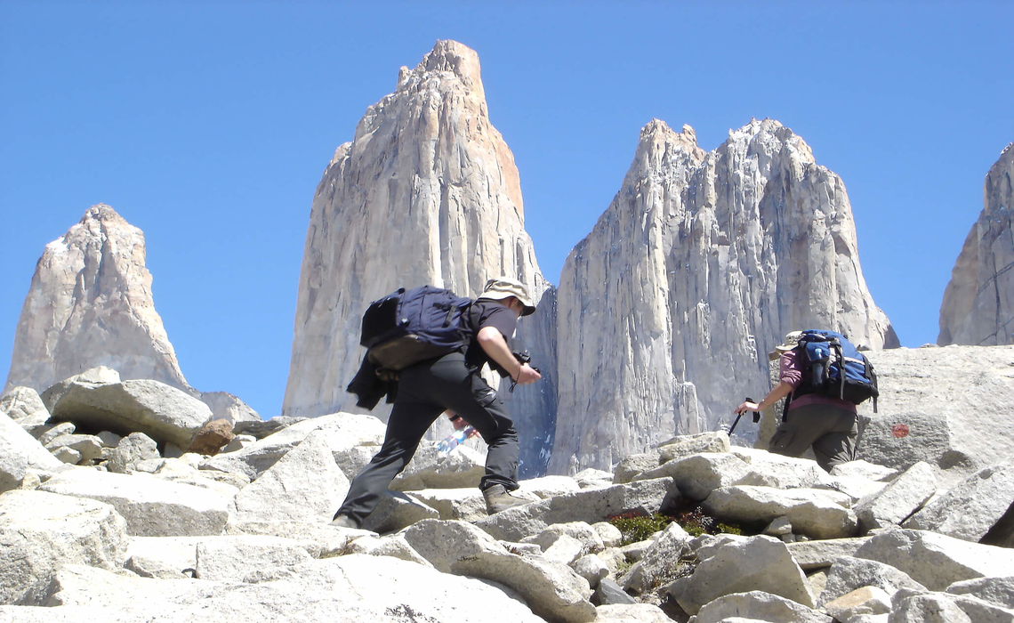
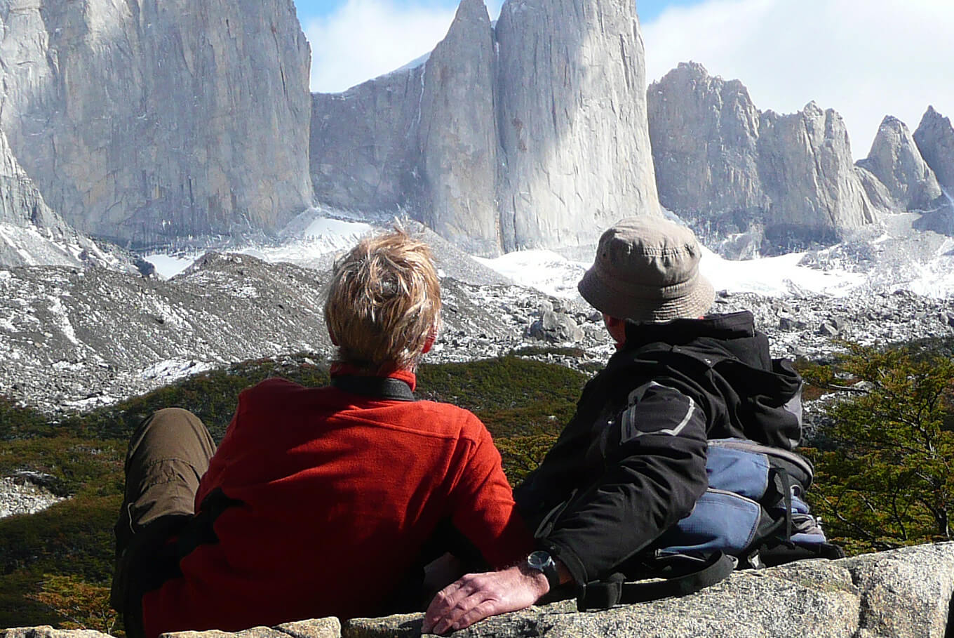
Shortly before arriving at the mountain lake below the Torres del Paine, the point from which the typical view of the three towers opens up, Vera's prediction comes true: the three peaks shine in all their glory. The sight that adorns many illustrated books and has become a popular motif on Instagram and co. is almost indescribable in person. We put in a sprint over the last hundred meters of altitude, but as soon as we reach the top and the camera is ready, the fog rolls in again. A quick snapshot, then it's over. The three magnificent cliffs are once again shrouded in a mystical veil. It's getting icy cold, our fingers are clammy despite our gloves, we wait, shivering and hoping. Will the Torres towers make another appearance? But the precious moment is over. Nevertheless, we are not disappointed, as we could definitely feel the magic of the place and the day hike to the Torres del Paine towers was just one of many highlights and the crowning glory of a unique trekking tour, the O-Circuit, through the Cordillera del Paine.
Annika Müller on the O-Circuit Trip January 2020